In the last lesson we discussed how to get the air to rise. That this rising air is the principal ingredient for thunderstorm development. Without it there can be no thunderstorms. We also described some of the ways to determine if air will be rising near you.
Once we have rising air, is this enough to tell you if thunderstorms will occur? No; it is a necessary, but not a sufficient, condition. In this lesson we will discuss what other things need to happen for a thunderstorm to form. Then we will discuss the different types of thunderstorms.
Once we have rising air we need a bit more to get a thunderstorm. Here is how it happens:
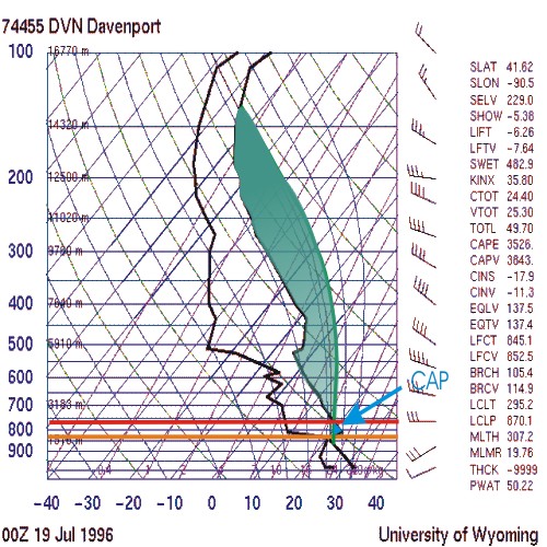
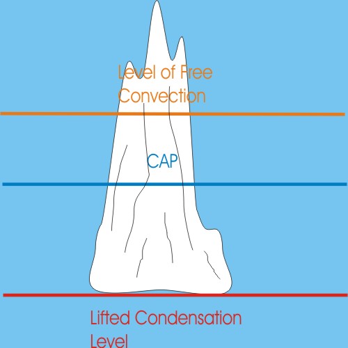
As a glob of air (what we will call a parcel) rises it cools. At a certain altitude (depending upon local conditions) it will reach a temperature where the gaseous water in the air (called water vapor) is forced out of the air in a process called condensation. This altitude is called the Lifted Condensation Level (LCL). This is the altitude where the cloud base develops. If we look at a Skew-T we can find this level, (here the LCLP) at 870.1 millibars (in this case a little higher than 1500 meters).

This is where we will begin to see cloud development, and the cloud bases will be at or a little bit higher than this level.
Clouds will rise (in this case a few hundred meters) before reaching an area where they are cooler than their surroundings. These same surroundings are also much drier, so clouds will evaporate into water vapor again. This is the area in blue called the CAP. If this cap is too think no globs of air will be able to pass through and there will be no thunderstorms. If this area is large, even if not thick, then the cap might be too strong (too dry or too warm, or both) for the parcels to penetrate and there will be no thunderstorms.
At this stage in development we would see clouds with dark flat bases and a bubbly appearance above, like balls of cotton with flat bottoms. A visual clue that a cloud is undergoing convection is a cauliflower-like appearance to the cloud tops.

Only if the parcels of air are allowed to rise to a certain altitude where they are once again warmer than their surroundings (due to the heat released by condensation) will they be able to sustain their own vertical development. This occurs because the water vapor cools and condenses cloud matter again, releasing a lot of heat. This altitude is called the Level of Free Convection or LFC (on this Skew-T it is the LFCT). Here you can see that this altitude is 845.1 millibars (around 2,000 meters high). Once a glob of air passes to this altitude it will be said to have "broken" the cap, and will then rise to a new altitude, called the equilibrium level (on this Skew-T it is EQLV, or 137.5 millibars, about 15,000 meters high; we would then estimate that thunderstorm tops could be as high as 50,000 feet).
As globs of air begin to break the cap we might see plumes of cloud extending up from the tops of the bubbly clouds we saw before. Such a structure might take on almost a tower-like appearance (which we then call towering cumulus, or towering-Q).
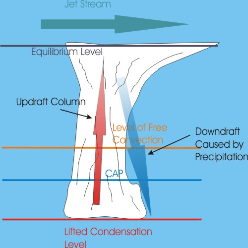
As the towers approach the equilibrium level the total number of water droplets increases and the droplets begin to coalesce into larger and larger droplets. Eventually this will form rain drops that will be propelled out in front of the developing storm by the action of jet stream winds at the higher altitudes (this is one reason why it is important for vertical speed shear to exist). As the top of the tower intersects with the upper level winds it gets blown off downstream, thus forming the classic anvil. As the raindrops accumulate out ahead of the rising column of air (the updraft column), the drops begin to fall to the ground. In some cases that temperatures in the anvil are so cold that despite the heat of the updraft the precipitation initially forms as snow, instead of raindrops. As the precipitation falls it turns to rain, and air gets pulled down by friction, and you get a downdraft out in front of the developing storm. At this stage you will begin to have ice crystals forming in the anvil. The collisions between these ice crystals can ionize the ice crystals (by stripping off electrons) and build up substantial accumulations of charge. If these become large enough lightning will result.
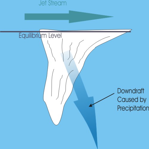
Eventually a thunderstorm will lose its updraft and the downdraft will continue for a time (and will likely produce precipitation and wind). After a time the only remaining part will be the now detached anvil cloud, what we call thunderstorm debris.
Discuss the development of thunderstorms.
There are basically two kinds of isolated storms. The first is your garden-variety thunderstorm, sometimes called an air-mass thunderstorm because it can form away from any fronts. The second is of great concern to us and is called the supercell thunderstorm.
Sometimes referred to as an air mass thunderstorm these storms are developed when a convective column gets strong enough to reach the LFC, or you get a boundary interacting with local prevailing winds, or some combination of these.
Such storms will generally have a very disorganized vertical wind profile. As such they will tend to be short-lived. This type of pattern will indicate that storms will tend to develop straight up, or nearly so. When precipitation begins to develop it will fall into the updraft. After a certain point the updraft will be overcome by the precipitation and the storm will dissipate. This takes, on average, 20 minutes.
This is a thunderstorm that develops a persistent and strong rotation about a vertical axis. Such rotation occurs in an area of a couple of miles in diameter and is called a mesocyclone. These storms are responsible for a good percentage of the severe weather that occurs.
As we can see from the Skew-T below,
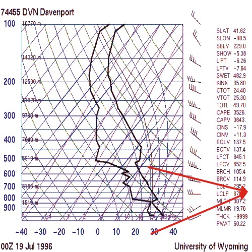
we have surface winds coming out of the southwest and winds about 700 millibars coming more from the west. This gives us an angle of shear of about 30 degrees. This means that there is a slight rotation about a horizontal axis between these altitudes.
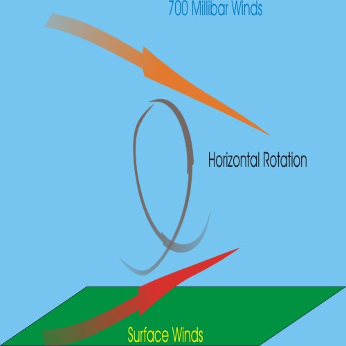
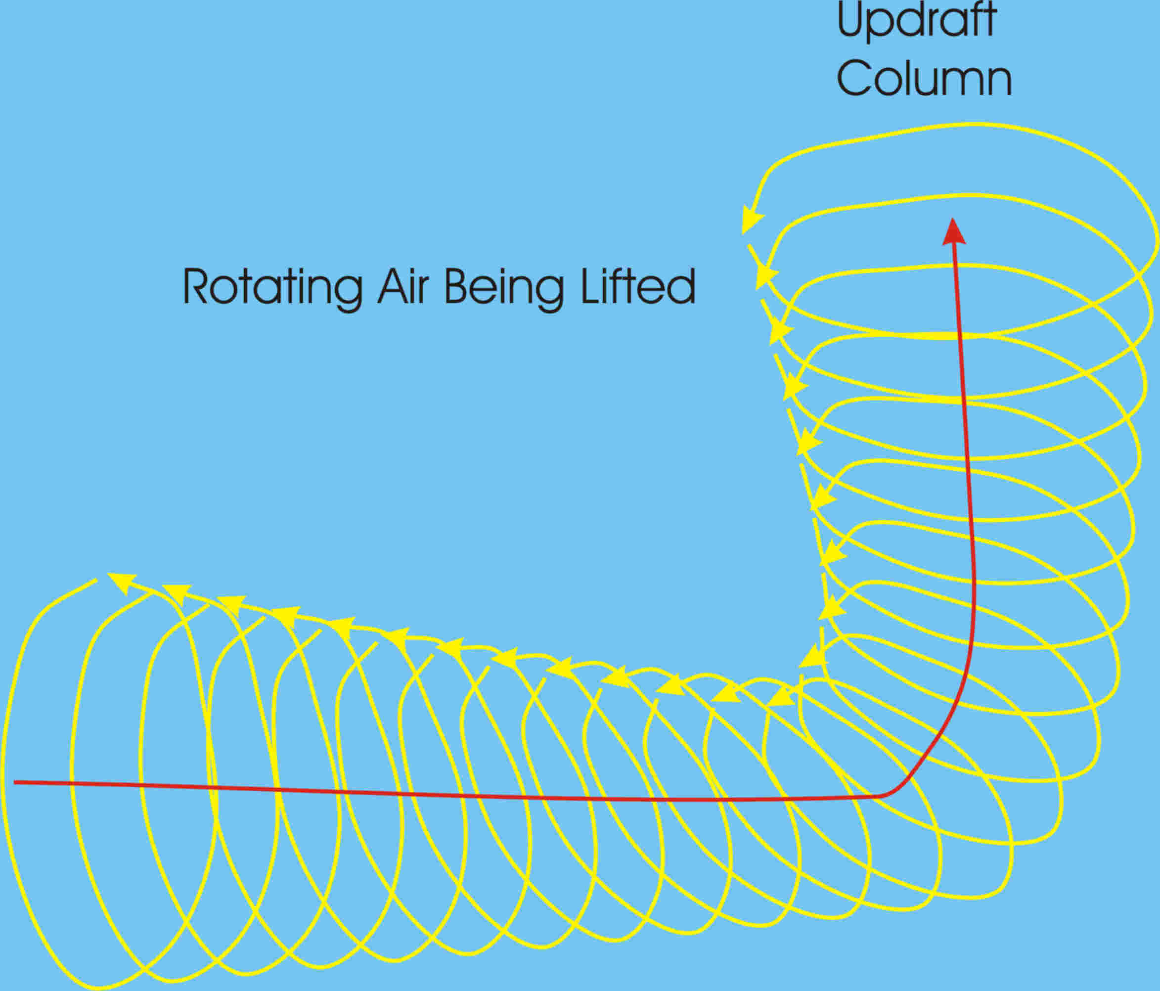
When an updraft or other vertical forcing mechanism occurs this rotation can become tilted upward. This will result in a rotation about a vertical axis. It is believed that this is one way that a mesocyclone is formed.
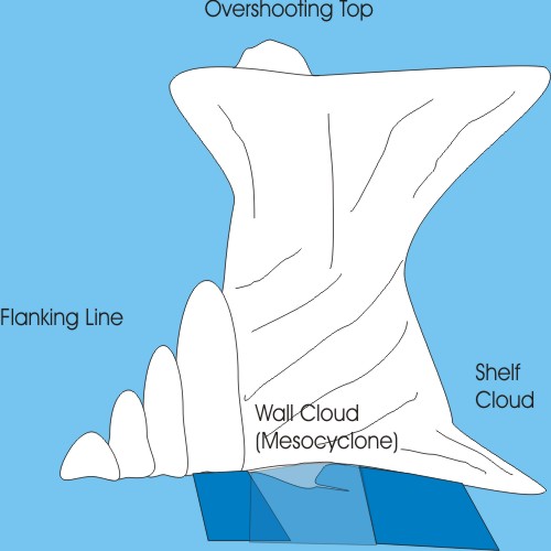
The classic supercell (which is rarely seen in nature) is depicted below. The updraft column is where the mesocyclone can be found. Note that this diagram has a visual clue that there is a very strong updraft present; there is cloud matter piling up above the anvil. This is called an overshooting top and indicates that the updraft is strong enough to punch through the jet stream itself.
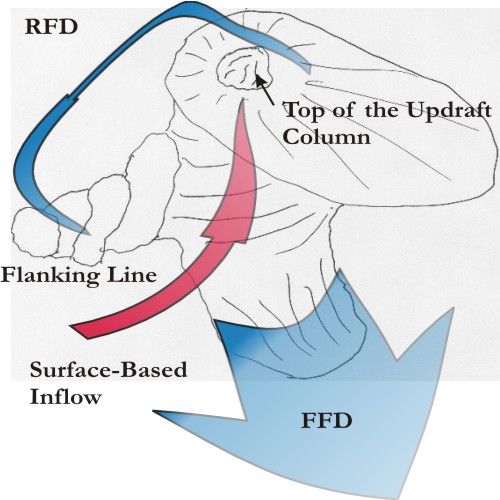
The flanking line contains developing thunderstorm cells that will replace the current dominant cell. Inflow frequently occurs at the surface and at both the 850millibar and 500 millibar level. Otherwise it is similar to other thunderstorms you might see. You might see broad and flat -looking ribbons of cloud matter flowing into the storm near the surface or aloft (at the 500 millibar level, for example). These are regions of warm-moist inflow, and are sometimes called beaver-tails because of the broad-flat appearance. When such bands are flowing into the storm, it is a visual clue that there is lots of fuel for the storm updraft. These are all clues that the storm will be long-lived.
The important thing to remember about supercells is that they are developing new cells in the flanking line that are being drawn into the thunderstorm as it progresses. The supercell will dissipate only when it looses the capability to generate new cells.
The classic supercell is almost never seen. Real supercells will be combinations of some of the characteristics of the classic mixed with either of the next two variants.
Some supercell thunderstorms develop in dry environments. These are called Low Precipitation Supercells or LP storms. They can form when mid-level moisture is the driving source of condensation. Often the precipitation goes into the formation of the anvil, rather than reaching the ground. Such thunderstorms are characterized by their high-bases. Storms like this are sometimes called elevated storms. These storms can form above existing low-level cold domes of air, in essence treating the top of the cold dome as the ground.
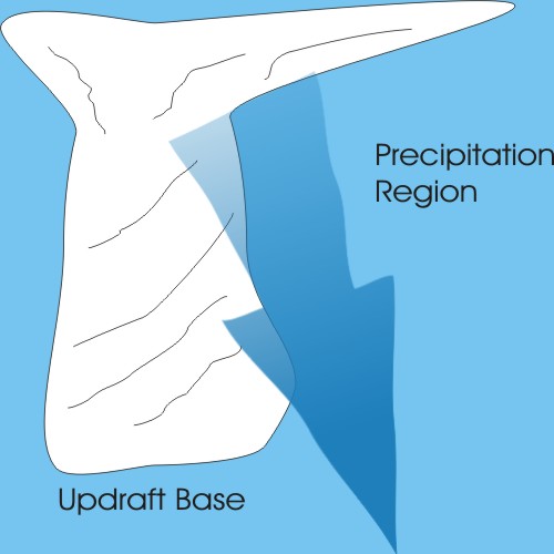
The other extreme occurs, too. Supercell storms that have an abundance of moisture are called High-Precipitation Supercells or HP storms. These are often the most violent storms that you can encounter on Earth. Note that rain is wrapping entirely around the mesocyclone, if there were a tornado in there, it would be difficult if not impossible to see; that is one reason why these storms are so dangerous.
Think about the level of danger posed by individual storms.
We now turn to collections of thunderstorms.
Frequently you will see a structure like this.
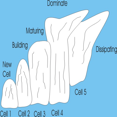
Here is a photograph donated by Virginia Randell of Kenosha, Wisconsin. Note the cells in different stages of development.
Here the storms are developing from the forcing point (where new cells are developing) downwind (to the right in both the drawing and the photograph). Successive cells will start, mature, become dominant, and then dissipate. This occurs in a line pattern extending downstream from the source of thunderstorm development. This is sometimes called a storm train. No cell will be likely to exist for more than a half hour. The severe threat from any cell is minimal, though the entire cluster can produce a lot of severe weather.
Frequently you will see lines of thunderstorms like this on the radar.
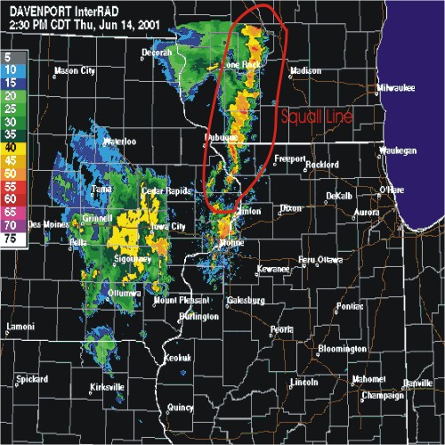
Where thunderstorm cells form on the right-hand (in this case lower) side of the line and propagate to the left (in this case upwards) through the line and eventually dissipate as the line itself moves forward (in this case left to right).
In some ways the squall line is reversed from the structure of a classic storm since its inflow is from the front.
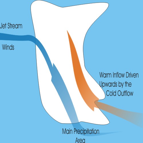
Here we see that mid- or upper-level winds can be brought down to ground level by the downdraft.
Here is one common way for squall lines to develop, we begin with a supercell that goes into the dissipating stage,
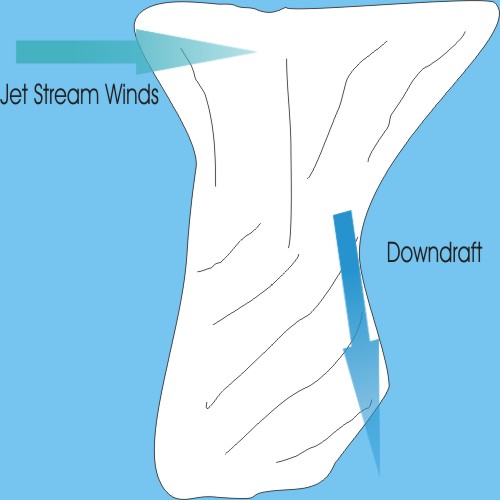
Mid-level winds are brought to the surface by the increased downdraft, this in turn causes strong outflow in the front of the storm. On radar there will be a characteristic bow echo.

This causes air ahead of the storm to be driven upward, creating a front-flank updraft. This in turn causes precipitation to fall on the rear-flank. This process continues until the upper level support ceases.
While it is very rare (I know of only two cases in my nearly thirty years of spotting and chasing) tornadoes can form in this forward updraft.
It is possible for regions of a squall line to develop supercell characteristics. Such a structure is called a Line Echo Wave Pattern or a LEWP.
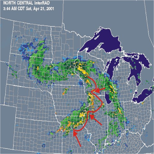
The cusps (indicated by the arrows) are the regions that will duplicate some of the characteristics of supercells. These places will have sufficient low-level shear to develop mesocyclones and will have sufficient inflow to support a strong updraft.
Occasionally, and usually at night, a large circular region of convection can begin to develop thunderstorms. This will last hours as new cells form on the outflow of dissipating storms coupling with the source of convection. Such systems are responsible for most of the summer nighttime precipitation.
Click here to back to the Spotter Basic Training Page
Click here to back to the Spotter Network Training page.
Click here to back to the Spotter Network page.
Click here to back to our home page.